Clements Hall
Nunnery Lane book cover

Clements Hall Local History Group

Exploring the Scarcroft, Clementhorpe, South Bank and Bishophill areas of York

Clements Hall Local History Group

Exploring the Scarcroft, Clementhorpe, South Bank and Bishophill areas of York

View navigation

De-industrialisation

The tide of industry turns

The York County History tells us that, in 1959, confectionery manufacture and the railway works were still the City’s leading industries. Of a total male working population of about 36,000 in 1951, about 7,000 were employed in transport (about 4,800 of them in the railways) and about 2,800 in building; of a female working population of about 18,000, about 5,100 were in confectionery, about 3,000 in the distributive trades, and about 2,600 in professional services. 

In 1953, the industrial element of Clementhorpe was still very evident. The air photo, below, shows the Fertiliser Works and Terry’s Factory. A large new shed has been added to the Bishopgate Street frontage. In the left foreground is the area once occupied by the slipway. 

CLEM - Shipyard scaled up
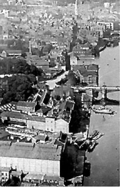
An aerial view of the industry at the north end of Clementhorpe (Photo courtesy of York Press, 1974).

A report[1] produced by York City Planning Office in 1975 drew attention to the adverse impact of industrial uses and unsightly former industrial land on the residential areas of Clementhorpe. “These problems relating to the layout and type of housing in Clementhorpe are further aggravated by outside influences on the residential environment such as conflicting industrial uses, and unsightly former industrial land.” The overall picture painted by the report is that of an area in the process of de-industrialisation.

Derelict and unsightly sites included storage and car parking on the Hargreave’s Fertiliser site, the vacant land where the Terry’s factory had stood, the cleared site of the former warehouse south of Fenwick Street and William Street, and off Lovell Street.

The Co-operative garage was a particular cause for concern, because its doors opened directly in front of the houses on River Street, thereby exposing residents to a variety of repair and servicing activities. The clothing and carpet warehouses on Cherry Street, and the vehicle repairers off Anne Street also created noise and traffic. The report recorded several other minor industrial and commercial uses. “The major unsightly sites in the area are the derelict residential properties on Cherry Street (soon to be demolished), the cleared land in Hargreaves site used for storage and car parking, the vacant Terry’s land, the cleared site of the former warehouse south of Fenwick Street and William Street, and the site of garages and demolished buildings off Lovell Street.”

The Study was accompanied by a number of plans showing the Planning Officer’s proposals. These are of interest here because the annotations tell us something about the state of the industrial buildings in Clementhorpe at this date (1975):

  • The Richardson’s/Hargreaves site is shown as “open storage and private parking.” The proposed use was for car parking.

  • The Terry’s Works is marked “Vacant Terry’s land and premises.” The original factory site is labelled on the base map as a warehouse. The proposed uses included car parking, housing or offices.

  • The whole boatyard and slipway are labelled “Co-op land”. On the base map the area closest to the Slip Inn is marked as a food processing factory, while the area nearest the river is labelled as a coal yard. There were no proposals to change the uses of this area.

  • The two large buildings between Terry’s and Bishopgate Road may well have been the clothing and carpet warehouses that are referred to in the text as still being in use, and they were to be retained.

  • The main Co-op buildings appear to have been still in use. The base map shows the two warehouses, coal yard and covered stables area. The suggested future use was for housing.

  • The land and buildings running from the rear of the Co-op to include the Parkside “Warehouse and Depot” were identified for possible retention in commercial use.

  • The site of the Nunthorpe Peel Works is shown as being vacant and suitable for an early phase of housing development.

  • Land adjoining this and lying to the south of Anne Street is labelled as a “Vehicle Workshop”, which could be retained in commercial use or else be used for housing.

  • The Maltings and adjoining school site could be retained for commercial use or developed for housing.

  • The DeLittle Works was to be retained.

  • Commercial buildings immediately east of Lovell Street would have been demolished to make way for the proposed Inner Ring Road, and included in an area of open space.

  • The site occupied by the Air family’s coal yard lay at the corner of Clementhorpe [the road] and Cherry Street. It was marked ”Derelict Houses”, and suggested for an early phase of house building.

The plan envisaged the retention of commercial buildings along the  River frontage, with residential property elsewhere. A new inner ring road would cross the River, continuing the line of Scarcroft Road.

A follow-up report in 1978[2] described the steps being taken by the City Council to remove industrial and warehouse premises from the Clementhorpe area. The policy was to replace them with housing, for example, on the site of the former warehouse in Cherry Street, or possibly for community facilities. A further warehouse had been acquired for housing, and two industrial sites, one of which was unused, had been acquired in Anne Street/William Street/Fenwick Street area – also for housing. 

The emphasis had changed towards residential development. Where industrial activities appeared not to impinge on residential amenity, it was proposed that they could continue. This applied to the main concentration of industrial activity along the River Ouse from Skeldergate Bridge to Rowntree Park. Indeed, this area was seen as having the potential for further commercial development.

To the south of Clementhorpe [the road] were the premises of the Co-operative Society, Shepherd Engineering Services[3] and the touring caravan park. The rear of the Co-operative Society building looked onto River Street, while Shepherds impinged on Lower Ebor Street. At this time there was still a proposal for a new inner ring road to run through the Shepherd’s site towards a new river crossing. The site was owned by North Yorkshire County Council and let on a short lease to Shepherd Development Co. Ltd., which may well have been related to the Engineering Services company mentioned above. In order to retain these sites in commercial use, but to improve the traffic situation, it was proposed to build a new access onto Terry Avenue.

The report describes the Co-operative Society premises as comprising a coal depot, pork factory, vehicle garaging and maintenance facilities, grocery warehouse, part of the funeral business, as well as the works of Crowder Engineering Ltd. In the longer term, the City Council wished to relocate these activities and develop the area for a mix of housing and open space.

The Terry’s premises on Clementhorpe [the road] were still in use at the time that the report was published – mainly for storage purposes. Terry’s had put the site on the market some 12-18 months earlier, but then decided that they still required it. In the meantime, a planning application was submitted proposing re-use of the premises as a hotel. This was approved in February 1977. The District Plan noted that, while the site was designated for industry, a hotel or office development would be appropriate.

Hargreaves Fertilisers’ site lay in two sections, the main part extending from Terry Avenue up to Cherry Hill Lane, and a separate warehouse along and to the west of Cherry Hill Lane. The main site housed offices and conference facilities, fronting onto Bishopgate Street, the remainder of the site being used for car parking. The Report noted that, at the time of writing, Hargreaves were moving their storage and manufacturing activities away from the Cherry Hill Lane premises. Their future was uncertain.

205528082.gallery
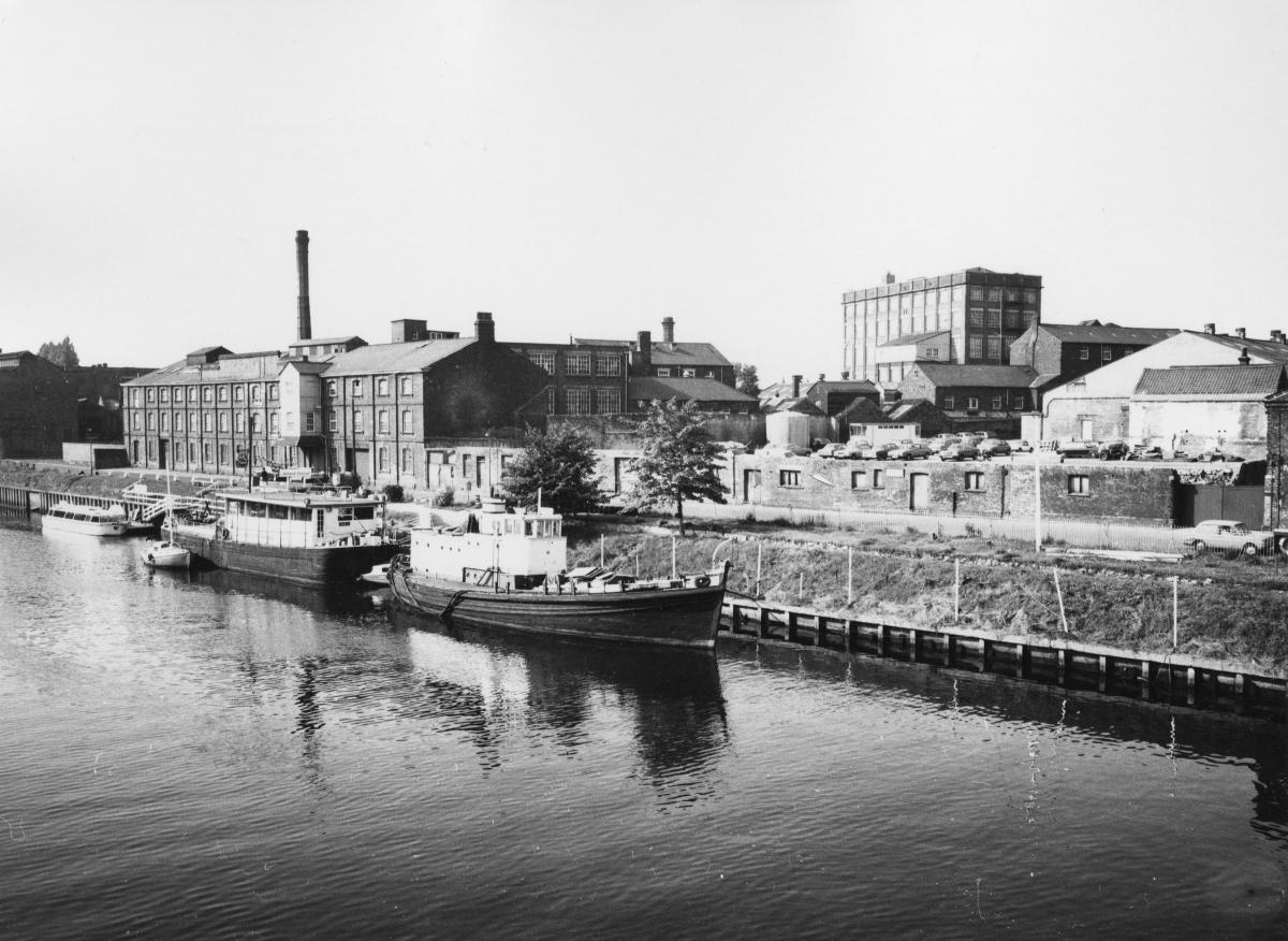
Terry's was demolished shortly after the photograph was taken on 6th August 1974. The remaining chimney was demolished in 1974 and the factory itself in January 1975.   By this time most of Hargreaves Fertilizer works had been demolished and was in use as a car park. (Source: York City Engineer)

CLEM - Coal Yard 1974 scaled up
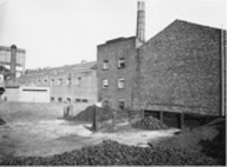
Terry’s looking north-west showing its coal depot in 1974, shortly before demolition. (Source: York City Engineer)
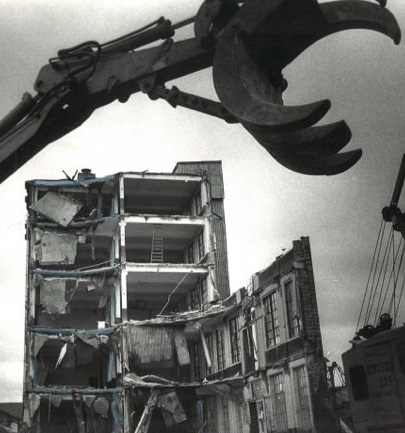
At this time too, the warehouse in Cherry Street had been purchased by the City Council, with only a year remaining on the lease. The Report looked favourably on the possible use of the site for social and community purposes.

The Malthouse in Lower Darnborough Street had also been purchased by the City Council, and was being used for storage by the Castle Museum. The Report wanted the building to be retained and improved.

The 1980s

A report produced in 1984[4] described the general condition of the area, focusing on the condition of the housing. Industry and commerce was only mentioned where it adversely affected the amenity of the residential component. A map shows housing clearance areas, and the coverage of the Housing Action Area (declared 1976) and General Improvement Area (declared 1981) – the last two being Government-inspired attempts to improve housing conditions.

A plan accompanying the report shows the layout of the Co-operative Society. Along the River frontage was a wharf with a travelling crane. The main warehouse and coal depot, with weighbridge, faced the River, with the bakery to the rear of the building, opening onto River Street. The Co-op Cottage faced onto Clementhorpe.

By this time the area of the earlier boat yard was occupied by a Food Processing Factory (east of The Slip) and a Coal Depot (on the corner of Clementhorpe [the road] and Terry Avenue).

In 1975 a survey was undertaken of the population’s economic and social standing. This suggested an unemployment rate of 9.3%, or almost twice the York average. 53.6% of the residents were in unskilled or semi-skilled occupations, with a further 15.7% in skilled manual and non-manual occupations.

The 1971 and 1981 Censuses of Population suggested that around a third of the working residents were still in manufacturing jobs, but almost 45% were in distribution and catering. The Report suggested that the redevelopment of the area had attracted a new type of resident – still mainly employed in manual work, but better qualified and capable of more skilled work.

Demolition Terrys

Terry’s factory during demolition in 1987. (Source: York City Engineer)

[1] Bishophill/Clementhorpe Local Plan Study: Preliminary Report, York City Planning & Estates Office, November 1975.

[2] Bishophill/Clementhorpe District Plan: Final Report, York City Planning & Estates Office, April 1978.

[3] Shepherds Engineering was part of the Shepherd Homes construction business.

[4] Clementhorpe 1983: A Social Appraisal, Thomas A. Roberts, Research Paper 24 sponsored by the Joseph Rowntree Memorial Trust, October 1984.