Clements Hall
Nunnery Lane book cover

Clements Hall Local History Group

Exploring the Scarcroft, Clementhorpe, South Bank and Bishophill areas of York

Clements Hall Local History Group

Exploring the Scarcroft, Clementhorpe, South Bank and Bishophill areas of York

View navigation

The early days

Clementhorpe Nunnery, founded by Thurstan, Archbishop of York, in 1130, provided the first hint of industrial activity in the area. Though small, it served an area bounded by the River Ouse, York’s city walls, the Knavesmire and the adjoining parish of Bishopthorpe to the south. The Nunnery supported agricultural activity, which included lime burning in two kilns close to the Nunnery walls.

The York County History tells us that there was a street called 'Mousecotes' outside Skeldergate Postern in the fourteenth century, but there seems to have been little further development.

By the sixteenth century, St. Clement's Priory owned two windmills near Clementhorpe. One of these was referred to as ‘Nun Mill’ in later sources. Nun Mill is shown on Lund's map of 1772 and was still standing in 1852.

The Mill’s continued existence is evidenced by the Leeds Intelligencer newspaper of 11 December 1823, that described the effects of a great storm in which “At Clementhorpe Hall[1] a stack chimnies [sic] were thrown down, and Clementhorpe mill was set on fire by the violent friction of the sails.” The last mill is said to have been removed about 1885, before the site was occupied by Southlands Wesleyan chapel.

Clementhorpe - Painting 1
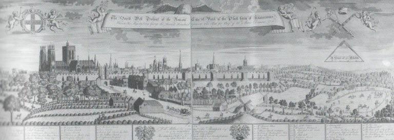
Could one of these ghostly forms be the Nun Mill? Detail taken from The South-West Prospect of the Ancient City of York with the Platform of Knavesmire, John Haynes, 1731. (Etching now owned by Ken Spelman).

The Nunnery was connected to the Ouse via Clementhorpe [the road], where a staithe may have been used to load and unload building materials and agricultural supplies. The Nunnery fell into disrepair in the sixteenth century, and today only one short stretch of wall remains, lying between Clementhorpe and Cherry Street. It has been suggested that, following Dissolution, further lime kilns may have been constructed. These could have made use of the materials left behind by the Romans and the demolished Priory.

P1030878
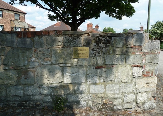
The plaque reads: “This wall is all that remains of the former Clementhorpe Nunnery founded in the mid 12th century by Archbishop Thurstan.” (Photo by John Stevens, June 2018)

Later centuries

The Royal Commission on Historical Monuments, in its report[2] of 1972 described Clementhorpe as an ancient suburb, with Clementhorpe [the road] having been the main street of a small village, running down to a staithe on the Ouse. After the dissolution of Clementhorpe Nunnery in 1536 the area went into decline, until small- scale development after 1823. The report suggests that there were a number of houses on Clementhorpe (St. Clement’s Place) around 1845, and on Cherry Hill in 1823-30. There is no mention of any commercial or industrial activity.

A private ferry near Skeldergate Postern facilitated crossing of the Ouse from Clementhorpe to the City Centre as early as 1541.  Later, in the eighteenth century this ferry was leased by York Corporation[3]. In 1873 the Corporation of York reported that more than 800 people a day were using the ferry crossing.

One of the earliest references to the development of industry in Clementhorpe is in a drawing by Francis Place, dated around 1710[4].

Clementhorpe - Painting 2
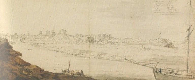
An etching[5] by Edmond Barker, dated 1718, shows us:

“Near to Skeldergate Postern, the river Ouse is a hive of activity. Ships moored at the ‘Craine House’ unload their cargo for a check by Customs and Excise. Outside the postern, a boat that has been hauled into the Clementhorpe shipyard and placed on stocks for repair. Meanwhile, on the river, the keels, brigs and barges scurry back and forth plying their trade.”

Image0001 etching

This reminds us that the industrial development of Clementhorpe’s river frontage is simply an extension of the development of the whole western bank of the Ouse, stretching all the way up to the site of Lendal Bridge. The whole length was, by the mid nineteenth century, lined by wharves, cranes, mills and other trading activities dependent on access to the river.

The York County History tells us that early nineteenth century York continued to be primarily a market centre for the produce of the surrounding countryside and a place where goods and services were sold. Many of the shops were supplied by handicraft producers, otherwise there was little in the way of manufacture.

In the 1823 Baines Directory there are only nine mentions of Clementhorpe traders, as follows:

Trade/profession

Name

Address

Brewer & maltsters

John Fryer Kilby

Clementhorpe

Butchers

John Fletcher

Lived in Clementhorpe, with a stall at the Thursday Market

Corn miller & flour merchants

Thomas Hodgson

Clementhorpe

Flax spinners

William Richardson

Skeldergate Postern

Sloop & boat builders

Thomas Birch

Skeldergate Postern


Joseph Turpin

Clementhorpe


John Nicholson

Skeldergate Postern

Tanners

William Richardson

Skeldergate Postern

Thread manufacturers

William Richardson

Skeldergate Postern


In the Piggot’s Directories of 1829 and 1841, there are some further entries:


Trade/profession

Name

Address

Boat builders

John Nicholson

Clementhorpe


Joseph Turpin

Clementhorpe

Flax dressers & spinners

John Scarr & Co. Ltd.

Clementhorpe

Merchants

John Scarr & Co. Ltd.

Clementhorpe

Shoe thread manufacturers

John Scarr & Co. Ltd.

Clementhorpe (1829 and 1841)

Maltsters

Christopher Scarr & Co.

Clementhorpe (1841)

Tanners

John Scarr & Co. Ltd.

Clementhorpe

Shoe Thread Manufacturers

Noddings & Co.

Clementhorpe (1841)

Shoe Thread Manufacturers

Caleb Fletcher & Co.

Clementhorpe (1841)

Little industry had developed in the Clementhorpe area. Most that existed was confined to the area just outside Skeldergate Postern. Some entrepreneurs were responsible for a number of businesses. For example, William Richardson was concerned with tanning, flax spinning and thread making, while John Scarr was a merchant, concerned with flax, tanning and shoe thread making[6].

Contemporary newspapers give us a few snippets concerning the industries and trades of Clementhorpe:

  • On 12 June 1830 the Leeds Patriot and Yorkshire Advertiser reported the death of John Scarr. He was aged 43, and a prominent Quaker.

  •  The York Herald of 31 July 1830 reported on a small boy playing truant from school. His father, William Worsdell was described as a “blacking manufacturer of Clementhorpe.” On the same date the Yorkshire Gazette reported that the son had gone missing.

  •  On 18 December 1830 the York Herald reported that a horse delivering manure to Richardson’s tar yard had taken fright and run into the river.

  •  The wonderfully named Perry’s Bankrupt Gazette of 9 April 1831 announced the bankruptcy of Christopher Scarr, Caleb Fletcher and William Simpson. They were described as “common brewers” of Clementhorpe.

  •  On 28 June 1831 the Chester Courant announced the bankruptcy of William Richardson a tanner of Clementhorpe.

Main period of economic development

The main development of Clementhorpe can be traced from the early nineteenth century up to the present day. Prior to 1851 there was very little development south of Clementhorpe [the road] except St. Clement’s Church, and this was already in ruins. A plan of 1856 shows the area south of Clementhorpe [the road] as a group of agricultural fields. This was grazing land, some of it lying below the normal flood level of the River Ouse.

The historic characterisation of the area[7] describes how “This area [Clementhorpe] illustrates how small self-contained settlements developed due to the demand for accommodation close to industrial areas during the Victorian period and on into the twentieth century.”

Clementhorpe - Painting 4

Scaife’s map of 1864 (below) shows some of the key features of Clementhorpe in its relatively early days. These include the buildings of the Nunnery, Clementhorpe Hall, the early industrial buildings along and north of Clementhorpe [the road]. We can also make out Cherry Hill House to the north and, to the south, Nun Mill sitting on the high ground. In the north east, the ferry across the Ouse at Skeldergate is clearly visible. Scaife’s map of 1864 (Source: Map courtesy of YAYAS Evelyn Collection)

Scaife map new version

[1] Clementhorpe Hall lay between Nunnery Lane and Price’s Lane

[2] City of York, Volume III, South West of the Ouse

[3] York Corporation Records, House Book 15

[4] York from the confluence of the rivers Ouse and Foss, by Francis Place, c.1710. Now in the ownership of York Museums Trust.

[5] The South-East Prospect of the Ancient City of York, Edmond Barker, 1718 in Views of York by York Civic Trust

[6] Dyed and often waterproofed (wax) threads used to stitch together the components of boots and shoes – generally leather, but also rope soles, cloth liners, etc.

[7] Character Area Statement, Area 71 Clementhorpe and Bishopthorpe Road, City of York, 2013, page 4.